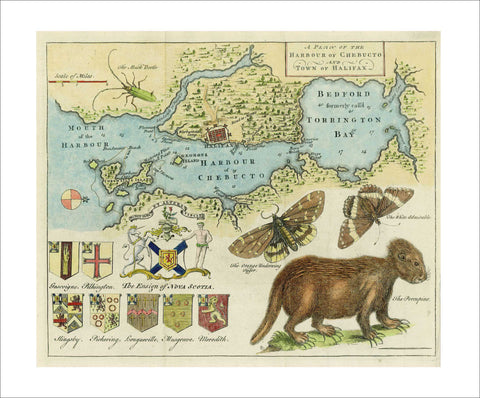
3537 Harbour of Chebucto and Town of Halifax, 1750, Harris
Description:
REPRODUCTION
A Plan of the Harbour of Chebucto and Town of Halifax
Mapmaker / Publisher: Harris, Moses
Date: 1750
Size: 11" x 9"
An amusing coloured copper-engraved map by Moses Harris depicts Halifax and its harbor, from “Cornwallis” (now McNab) Island to the head of Bedford Basin (formerly called “Torrington Bay”). What is now the North West Arm of the harbor is here “Sandwich or Hawk's River”. South of Halifax is “Warburtons Camp”, with “Col. Gorhams” north of town. The site of Dartmouth is occupied by “Major Gilmots”. Moses Harris was a noted eighteenth century entomologist who had training as a surveyor and served in that capacity when he came with Cornwallis in 1749 and laid out the new town of Halifax in that same year.


